(back to Tongariro - Part One)
Sunday, March 12, 2006 (continued)
 I woke up at Discovery Lodge exhausted after the first Tongariro Crossing the day before. After settling my bill, I drove to Wellington and caught the ferry to Picton on the South Island. It was a relatively easy process to drop my "flash" car in Wellington, ride the ferry, and pick up my not-so-"flash" car (a Mitsubishi Lancer) in Picton.
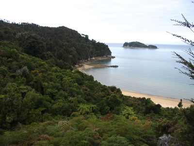
Soon I was driving along the coast towards Abel Tasman National Park. The photo to the right was taken on the way to Abel Tasman. Views of bays like this were all along the way. Unfortunately, during the ferry ride and during this drive a cold developed in my head. Might have been the cold, wet Tongariro Crossing hike the day before, or it might have been sleeping in a tent without a hat. But I stopped in Nelson for the night, bought cold supplies (tissues, throat drops, a knit cap...) at a store that reminded me of a Wal-Mart or K-Mart. I pitched my tent at Brook Valley Campground just outside of Nelson.
Monday, March 13, 2006

 I woke up relatively late at Brook Valley Campground. It was hard to get going with the cold in my head. But eventually I was on the road heading for Able Tasman National Park. At the recommendation of Kain (who I met in Auckland) I went to The Barn Campground and pitched my tent.
My campground was less than 100 yards from the Marahau entrance of Abel Tasman National Park, so as soon as I was organized I set out to explore the place. After crossing three bridges over a lovely estuary, I turned around and took this photo on the left... then turned back to continue along the track. The photo on the right is essentially what the trail looked like - a tunnel cut out of rainforest. As I walked along the "tunnel", I knew the beach was to my right and I was looking to sit and relax on the beach for a little while.
 After about a quarter mile, I came across a little side trail with a sign that said "Porters Beach" - see the photo at left. It looked interesting, and certainly would take me to the water, so I took it....
It opened up onto the beach at very low tide. I walked all the way out to the water which you can barely see in the photo below - that's my shadow, by the  way.
way.
The tide was coming in and I thought it would be interesting to watch it come in. So I chose one of the little "islands" (mine was only about 10 yards across) of sand in the estuary. Actually, it was just a patch of sand slightly higher than what was around it. I sat at the very middle of it and watched the water very slowly creep up around me as the tide came in... eventually my little "island" got smaller and smaller until is disappeared completely.
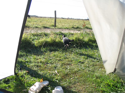
 By the time I decided to head back to my tent, it was dusk and the birds were becoming more and more active. This cheeky little bugger in the photo to the left seemed to be leading me somewhere. He always kept himself just a few yards ahead of me... just beyond the distance for a decent photo... so I had to enlarge him into an inset so you could see him. Pretty, huh? New Zealand doesn't have any native land mammals, only birds. It used to be part of a huge land mass with Australia, South America, etc. When it broke away it didn't have any mammals on it, so they didn't evolve here... but lots of interesting birds evolved here. Their dinosaurs include a huge ostrich-looking dinosaur that is almost two stories high! I saw a model of one in the Auckland museum. When I saw the phrase "New Zealand Wildlife", I had to remember it was probably birds and marine life.
Oh, dusk is also when the sand flies came out in this region. I often walked around barefoot in New Zealand, and my ankles got all bit up by those sand flies. And the bites itch like you wouldn't believe. I started wearing socks and shoes after that for the rest of my time in Abel Tasman.
Tuesday, March 14, 2006
 When I woke up my head was really hurting from my cold, and it was warm and dry here, so I decided to give myself a lazy day in the tent. I spent the morning dozing, reading, etc. Also, the photo to the left is what I saw out of my tent door. Across a gravel road was a horse pen with three horses - I think they were used for tourist beach rides. Every now and again they would run back and forth along this fence. It was nice to hear their neighs and hoof steps.
There were also birds in the campground and if I kept quiet enough, they came very close to the door of my tent. The large photo below shows one of those birds just outside my tent. The little dots just above the bird, way in the back on the horizon are actually hikers crossing the first of the three bridges across the estuary. That's how close I was to the trailhead! :-)
 To the right is a close up photo of four of the birds I mentioned - all together near the trailhead... notice their really long legs... they're like that bird in the old bugs bunny cartoons, with the silly clucking music. I think it was called a Myna Bird. And remember the Tasmanian Devil... makes me think someone on the design team for Warner Bros. was a kiwi or maybe an aussi...
The first unfortunate event of the trip happened on this day. I thought I had locked the keys to my rental car IN the car. I looked everywhere and I couldn't find them. I eventually had to call Budget and they sent someone out to break in... but the keys weren't in the car. I though it was going to cost me $300 to replace the key (it had an electronic door opener and security code in it) and I was worried that someone had taken the key and might try to steal the car during the night. But later in the day I found the key laying next to my tent. It must've fallen out of my pocket when I went out to open the flap and let in the warm breeze.
One upside of the "lost" rental key incident is I met a really nice Swiss guy, named Erik. He tried to help me not stress over the lost key. And he laughed with me when I showed him I had found the key. We talked until pretty late in the evening - and we decided to meet for dinner after our activities tomorrow. I was going to do a good long day hike, he was going to go kayaking along the coast. He was very quick to mention his girlfriend very early in our conversation, so it was nothing romantic or anything. We just hung out and chatted.
 I took this photo at the left after the sun had set. There was just enough light left to take it. That's the moon over my tent... and that's a picnic table next to my tent.
The little hill on the horizon, just above the picnic table, is actually an island just off the coast. That's how close I was to the water. Unfortunately I still couldn't hear the surf at low tide, and I could only hear it a little at high tide.
Wednesday, March 15, 2006
 I was feeling pretty good when I woke up - my cold was starting to break - and I was ready for a good day hike on the Abel Tasman Track . I had a late start, but eventually was on my way. At the beginning, I basically retraced my steps to Porters Beach and continued on from there along the coast. The photo to the left is of typical rainforest that I saw so much of during this hike.
Then out of nowhere, a giant kiwi bird, at least twenty feet high leapt out from among the ferns and attacked me! It knocked me over and I scraped my knee as I fell down into a rocky ravine leading to a bay about thirty yards below.... Ahhhhhh! No, not really...

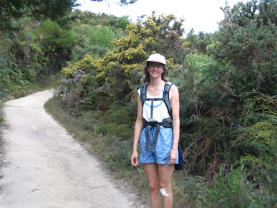
The truth is I was feeling so good I started out at a really good pace, despite my aching arches... but a bit too fast, I think. For some reason, I fell into a heap right there in the middle of the trail. I still don't know WHY I fell, but it was surprisingly nasty. For a few awful second I thought for sure I had REALLY messed up my ankle and wouldn't be able to walk back to camp on my own. But as it turned out, when I eventually stood up and tried to walk on it, I found I had only sorta strained on right ankle a wee little bit - I could walk just fine. I did badly scrape my left knee though. More in the interest of practicing with my first aid kit, I sat down and cleaned up the scrape, disinfected it and taped a bandage on it. It wasn't pretty, but it was an interesting task to pass the time while I let my body recover a bit from the excitement of the fall. The photo at the right is my artsy-fartsy photo of me hiking. See my bandaging job?
When people asked about my knee over the next few days, I told them I fell for some reason... they said I should make up a very interesting story to tell when people ask... so that's the reason for the giant kiwi story... if you've ever seen an actual kiwi bird you would know they only get the size of a football at best - hehehe...
The Abel Tasman Track is meant to be a 4-5 day hike, with hiking huts spaced appropriately. The huts were all booked so I couldn't do an overnight, but that was okay with me. Lots of folks said that day 1 of the trek is the same as all the other days... hiking through rain forest and side paths to lovely bays.
 I pretty much got as far as the first hut and then turned around and went back to the start. Just before the hut, I saw a sign for a path off main track that went down through a forest to a place called Watering Cove. I suspected there would be less foot traffic to Watering Cove because there was another path leading to another bay that was much closer to the main path.
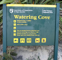
I was right, there was less foot traffic... but there were quite a few kayakers that had paddled up to the shore from the water. To the left is a photo down in the cove for kayakers who float up to the shore - it was typical of DoC signs. I mentioned to cove to Erik later on, and he said his kayak group had stopped there too, probably just before I got there. Apparently it's popular with kayaking companies. But it was okay because after lunchtime passed, I had the entire cove to myself for about a hour - except for a pair of German teenagers who kayaked in for a few minutes and asked me to take their photo. The photo below seemed worth enlarging for this page... this is after the kayakers left and I had it alllll to myself. I leaned up against a log looking out into the cove... and took a little snooze... ahhhh....

I took few more photos just before I left. These are some of the rock formations that straddle the cove.


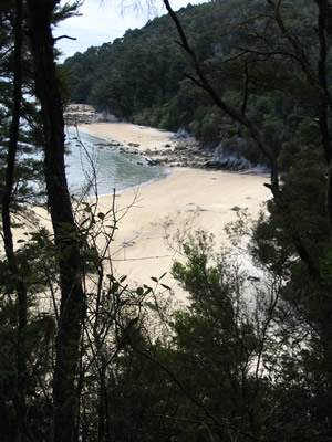
I got shutter happy during the return hike. I'm glad I did because these photos might give you an idea of how beautiful this place is. I couldn't chose one out of the group so I'm putting all of them up here. Below are a two photos of the various bays you can see from the trail...
 The photo to the left is the estuary I walked across when I first got to Abel Tasman National Park - mentioned above. The streams of water you see crisscrossing the sand are actually freshwater streams flowing into the sea from the land. See how they make little "islands"? I watched one of them disappear as the tide came in.

The photo at the right is a relatively big streambed carrying water out to the sea.
I asked a passing hiker to take this photo of me (to the left) near the end of the hike. Nice bandage, eh?
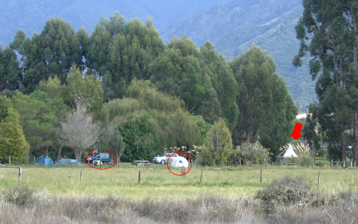
I took this photo below on my way back across the bridges. The red arrow shows the teepee that Erik slept in with 6 or 7 other tourists. The red circles show my tent and my rental car. As you can see the horses were out for a ride just then.
Erik was waiting for me in the common room when I got back. Even though my feet hurt a ton, we walked another half mile to a really nice restaurant just down the highway called Hooked on Marahau. I had a delicious roasted chicken and he had a beef steak. The food took quite a while, but we had some wine, conversation and we watched a lovely sunset over the sea. It was interesting to hear the perspective of a Swiss on current events, history, politics, etc. Unfortunately, I forgot my camera in my backpack, so I never got a photo of Erik. He looked exactly as you might imagine a Swiss would look... blond, blue-eyed, average height...
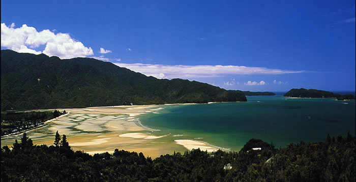
Below is a photo I scanned from a postcard (Copyright: iantraffordphotos.com)... none of my photos come close to doing the beauty of this place justice... this photo does a much better job. My tent was on the very left edge and the hike went along the coast you see across the bay and all the way to the land you see in the distance... and beyond...